
Use AgFiniti® To Scout This Year With Multi-Year Analysis Maps for FREE!
This year, scout your fields with your operation’s information at your fingertips. View Multi-Year Analysis maps through AgFiniti® and get the big-picture view of your operation to advance farm management decision making.
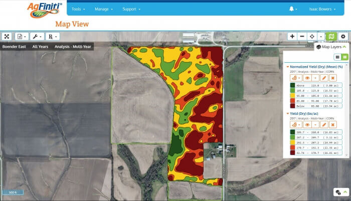
Multi-Year Analysis maps average multiple years of grain harvest data to help you see yield trends and easily identify management zones in your field. These zones are helpful for making in-season and post-season management decisions. While Multi-Year Analysis maps can be used to create prescriptions for the field based on nutrient needs, they can be used for even more. These maps serve as a valuable reference layer along with other maps (e.g. hybrid or variety maps) while walking fields, helping to identify specific areas to make improvements during the current or following year.
AgFiniti makes it easy to see these maps by automatically generating them as new grain harvest data is uploaded from Ag Leader InCommand® displays, legacy displays (Ag Leader® Integra or Versa™), or SMS™ Software.
How To Access the Free Trial
- Verify you have an active AgFiniti Essentials license. If you don’t, please reach out to one of our Ag Leader dealers.
- Purchase a Prescriptions and Multi-Year Analysis service for a field in AgFinitiand enable the option to try one field for free (up to 120 ac). Your Multi-Year Analysis maps will be automatically generated!
- Go to the field with our AgFiniti apps for Android or iOS!
Don’t wait till harvest to make use of Multi-Year Analysis maps. Try it now through a free trial today!
Talk with an Ag Leader dealer or see the AgFiniti page to learn more!