
Water Management Pre Season Tips Part II
In the second installment of this blog, we will talk about preparation for laying out tile, how to create tile plans and the software tools available to make the job easier. The first installment of this blog series can be found here.
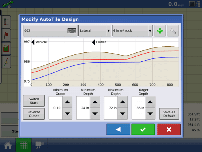
If a tile plan has been built and exported from SMS™ software, that plan can be imported to the InCommand® as a reference where the tile is intended to be placed. If using the tile plan to install, it is crucial to make sure the plan was built based off accurate elevation data.
In the display, take the surveys that were created in the tile plan and verify that all of the install parameters (See figure 2) are accurate and match with where you want to place the tile.
-or-
Create a new survey with the display for where you want the tile to lay in the field. Then check over parameters (See figure 2) to ensure accurate tile placement. The Intellislope® system can be used standalone, without any preplanning in SMS.
In both cases when setting install parameters it is always good to keep in mind both the max depth the tractor can pull the plow and the amount of ground cover (minimum depth) the grower wants over the tile to avoid interferences with other field operations, like tillage.
After completing the tile installs, the install data can be exported out of the InCommand display and imported into SMS for post analysis, map printing, and record keeping. Continue reading to learn more about some SMS tools that can be used when making a tile plan ahead of time.
Tile Planning and SMS
SMS Advanced software provides a number of tools to help analyze fields you wish to tile. One of the most helpful is Terrain Analysis. Wetness Potential, Watershed ID, Elevation and Drainage Area are just a few of the attributes that Terrain Analysis generates. It is also important to remember to use highly accurate GPS data when setting 3D grids and using Terrain Analysis. Other layers that you can use to help focus tile include maps that you can get today such as soil survey layers, yield data, and imagery that may show water stress through the growing season.
Water Management Tools
The Water Management tools will allow for the placement of tile runs in specific locations that follow unique specifications. These tools do the hard work for you, taking into account tile size, soil types, drainage, elevation and slope in order to determine if the system is flowable or not. In addition to making sure water will flow through the system, SMS also helps prevent issues such as silting-in or erosion from occurring. All of these options working together will help to generate the best possible tile installation while taking a lot of the guesswork out of planning.
Exporting a Tile Plan
Once the tile plan is valid, it can then be exported out to an InCommand 1200 display with Intellislope as mentioned previously. A plan can be exported like any other prescription or boundary, by using the Device Setup Utility. Once the plan is in the Ag Leader InCommand, it can use the individual runs as survey lines, greatly speeding up the install process.
For more Intellislope resources, check out the InCommand Feature User Guide and the Ag Leader® Integra Quick Reference Guide.