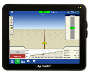
Design Tile Drainage Systems in Your Fields with the SMS Tile Plan Editor!!
One of the new features that we are excited to release in version 12.5 of SMS Advanced is the new Water Management Module for tiling. This new optional editor allows you to design tile drainage systems in your field by utilizing RTK level GPS elevation data. You can utilize any reference layer such as soil survey data, harvest data, planting and imagery to assist in the design process. Using these layers you can strategically place tile in the areas you need it the most.
The editor allows you to set constraints on how shallow, how deep, and the minimum grade to maintain adequate water flow. If you have drawn lines or collected data that doesn’t have a flowable solution, you are provided a warning and details on how much interference exists. You can then change the constraints or draw the line in a different location.
This editor allows you to make several designs so you can compare drainage plans for the amount of tile needed, and which plans allow the most grade. As time goes on, we will continue to add features and tools for other Water Management plans in SMS. Contact Ag Leader today about this new module to see how this can benefit your operation.
Click here to sign up for a free webinar that will cover the Water Management Module.


