
GPS Differential Sources Explained
Many times when new comers to precision agriculture start to think of how to apply the technologies available on their farms, they struggle with choosing the correct level of precision for their intended use of technology. For a high level overview of differential correction, check out http://www.agleader.com/2010/07/01/lessons-in-precision-ag-differential-correction-part-1/ There are many service options available and depending on what you plan to do with it, this choice will make or break the success you will have with your new purchase. The three dominant GPS differential correction sources available are WAAS, OmniSTAR and RTK. The differences between the three can be substantial. This information will help you decide which source is right for your operation.
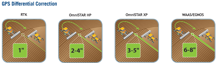
WAAS & OmniSTAR WAAS is a satellite based correction source that utilizes ground stations to generate a correction and broadcast it via a radio signal. The correction is derived from combining the data from GPS satellites taking into account the GPS satellite orbit, clock drift and timing delays. It is calculated by ground stations across the US and is broadcast through three geostationary satellites fixed over the equator. Using WAAS will get a user 6 – 8 inch pass-to-pass accuracy. OmniSTAR is a wide-area differential GPS service. It uses GPS satellite data and ground stations similar to WAAS to derive a multi-station correction to increase accuracy over the service area. OmniSTAR offers two types of service: HP and XP. The HP signal is a higher accuracy solution providing the user 2 – 4 inch pass-to-pass accuracy. The second service is labeled XP and offers the user 3-5 inch pass-to-pass accuracy. To find out more about these options, you can find more information: http://www.agleader.com/2010/07/06/lessons-in-precision-ag-differential-correction-part-3-omnistar-and-waas/, http://www8.garmin.com/aboutGPS/waas.html or www.omnistar.com.
RTK RTK offers users the highest accuracy available in GPS technology. It combines GPS satellite data with a ground station in the same location as the user to broadcast a correction via radio or cellular data connection. The increased accuracy is possible because the ground station is broadcasting from an area within miles of the rover; therefore the conditions of the two are virtually the same negating accuracy compromising differences in the atmosphere. With this technology it is possible to achieve sub-inch pass-to-pass accuracy and year-to-year repeatability. Go to http://www.agleader.com/2010/07/02/lessons-in-precision-ag-differential-correction-part-2/ for more information.
GPS Products from Ag Leader Technology Ag Leader Technology offers GPS receiver products to satisfy your GPS needs at all levels of precision utilization. Check out http://www.agleader.com/products/gps/ for more information on our current product offerings.
| Applications |
ParaDyme |
GPS 1500 |
GPS 2500 |
| Guidance |
x |
x |
x |
| Tillage, Disking |
x |
x |
x |
| Harvesting |
x |
x |
x |
| Field Preparation |
x |
x |
x |
| Mapping (Point, Line, Area) |
x |
x |
x |
| Variable Rate Controllers |
x |
x |
x |
| Spreading |
x |
x |
x |
| Spraying |
x |
x |
x |
| Applications |
ParaDyme |
GPS 1500 |
GPS 2500 |
| Seeding |
x |
x |
x |
| Log Hybrid/Variety |
x |
x |
x |
| Listing |
x |
|
|
| Cultivating |
x |
|
|
| Bedding, Ridging |
x |
|
|
| Strip-Tilling |
x |
|
x |
| Topographic Mapping |
x |
|
|